
Monongalia County Search Steps
Monongalia County rewards a short chain of lookups rather than one big search. Open the Assessor's database first. It accepts a street, city, development name, owner, sale range, acreage range, or book and page. From the result, grab the parcel key. That key unlocks values and sales history. It also carries into the state assessment product or the map viewer. A sale or ownership change works differently. Search the County Clerk's IDX by party and document type. The assessment name is not a new deed. Keep the steps separate, because the systems do not sync in real time. The assessor database covers current parcels by default. Uncheck its current-info control to reach historical records. The statewide Viewer updates ordinary ownership and assessment data annually, so a recent ownership change may not appear yet. For older searches or hidden images, ask the county office which book, counter terminal, or copy route covers that record.
- Enter a street name and city, or search the owner’s last name in the county assessor database.
- Copy the parcel ID, development label, and any book or page reference that appears.
- Use the IDX to check the grantee deed and related instrument by name or record type.
- Compare the same parcel in state assessment and the WV Property Viewer.
- Contact the clerk, assessor, or Sheriff for a counter copy or a record not exposed online.
Monongalia Assessor Search Fields
The county database offers more than a single street lookup. Its extra fields matter when an address is incomplete. They also help when a parcel sits inside a named development and the roll runs long. One toggle matters most. Leave the current-info box checked for current parcel information. Uncheck it to pull historical results instead.
| Portal field | Type | Use in a Monongalia search |
|---|---|---|
| District, Map, Parcel, Parcel Range | Dropdown and text/range | Find a known tax-map identifier or range. |
| Last Name, First Name/M, Business | Name and checkbox | Find individual or business owner entries. |
| Development, Street Name, City | Dropdown and text | Search a named development or block. |
| Deed Type, Date From/Through | Dropdown and date ranges | Narrow deed or sale-history records by period. |
| Sale Price, Acreage, Book, Page, Area | Ranges and text | Screen by reported transaction or recorded reference. |
| Plat, Multiples, Life Estate, Minerals, Not Mapped, Void, Duplicate | Criteria controls | Locate special assessment cases and map exceptions. |
The Monongalia County Assessor parcel database is the source for these search controls.
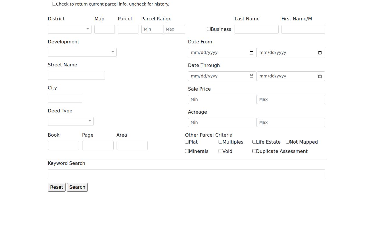
Confirm the first result set. Only then add a second filter. But note this is guidance for narrowing: start with one known field.
Monongalia County Parcel Number Formats
A parcel number is the cross-office key. It joins a street address to the assessor, the map, and the deed reference. The full West Virginia ID has six parts: county code, district code, map number, parcel prefix, parcel suffix, and special ID. Monongalia uses county code 31. One published example is 31-05-0007-0031-0015-0000. Shorter versions exist. A GIS ID drops the special ID, the CAMA/IAS version drops the county code, and a short map-parcel label may look like 05-7-31.15. Never shorten an ID for another portal. A split or combined lot can change the geometry. A new line may reach the statewide file only after the deed is recorded. When the county database and the state viewer return different formats, copy both exactly as shown and compare district, map, parcel, and suffix before deciding they point to different land.
Monongalia County Address Search
The statewide Viewer takes an E-911 street address. A format like “98 Beechurst Ave, Morgantown, WV” works. It draws on the Statewide Addressing and Mapping System, and it refuses rural routes and post-office boxes as the situs key. The county assessor instead offers Street Name and City fields. Cross-check when something looks off. An abbreviated road name, a changed number, or a parcel on an unincorporated edge can throw a match. Use the parcel or owner result to confirm. A mailing address is not always the physical address. The Viewer can show the owner's mailing address apart from the parcel's physical location. ZIP geography can cross municipal limits too. Morgantown, Westover, Star City, and nearby communities may share postal conventions that say nothing about which city's permit rules apply. Rely on the actual E-911 location and a municipal boundary map when jurisdiction matters, and remember that the state assessment search offers county, district, owner, street, map, and full parcel-ID modes.
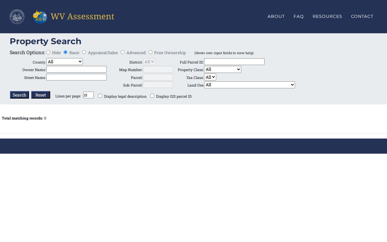
Basic, Appraisal/Sales, Advanced, and Prior Ownership modes offer fallbacks.
What a Monongalia Result Shows
A property-search result may bundle an owner name, parcel number, address, and assessment data. The cards differ, though. The state and county cards are not identical. Confirmed state headings include Parcel Attributes, Delinquent Status, Community, E-911 Address, External Links, Flood Info, Description, Property Owner, Physical Address, Building Information, Cost Values, and Appraised Values. A county result adds its own angles. Fields there include development, sale price, deed type, acreage, book, and page.
| Property Owner | Name displayed for the assessment record; a summary may show only one person. |
|---|---|
| Physical / Mailing Address | Parcel situs and owner correspondence address can differ. |
| Parcel ID | Full or shortened format used to cross-reference state and county systems. |
| Cost / Appraised Values | Assessment measures, not a sale appraisal or current offer price. |
| Description | Parcel description and legal-description link or report where available. |
| Flood / Delinquent Status | Map context and status flags, each requiring source and date checks. |
Some headings need caution. Card labels for last sale, exemptions, or owner mailing fields vary by system, and no sample deed result sets the pattern. Do not assume those fields exist just because another state uses them. The IDX inventory is different. An index result can display index, image, flag, status, date, document, book-page, page count, sub-index, name, cross date, and instrument. Read the recorded document when a legal detail matters.
West Virginia Assessment Search Modes
The state search works well as a second view when a county query is hard to frame. Basic mode starts broad. It accepts county, district, owner name, street, map, parcel, property class, tax class, sub-parcel, and land use. Appraisal/Sales and Advanced views widen the field list. They add ranges for land, building, and total appraisal, plus calculated or deeded acres, sale date, and sale price. Recorded entries also cover mailing address, flood hazard, deed book and page, legal description, building year, structure types, and building area.
Prior Ownership mode reaches older assessment names. It still cannot replace the clerk's deed chain. A state record may carry an IAS/CAMA parcel format without the county code, so compare the district and parcel components with care. The state's FAQ notes annual assessment updates. It also directs users to the local assessor when a new deed or parcel line has not appeared after the stated update period.
Choose a Monongalia Search Key
The right key depends on the job. One-site lookups, name sweeps, and identifier transfers each call for something different. Address is fast when the E-911 entry is correct. Owner name can pull multiple parcels or false matches. Parcel ID gives the tightest cross-reference, though formats differ across the county assessor, the state assessment site, and the GIS display.
| Search Key | Best For | Where It Works | Watch Out |
|---|---|---|---|
| Address | Locate one parcel or street block | County Street/City fields; WV E-911 Viewer | Rural routes, PO boxes, and postal-city edges do not work as situs keys. |
| Owner name | Find parcel entries tied to a person or entity | Assessor Last/First and state Owner Name | Same names, trusts, estates, and LLC suffixes need confirmation. |
| Parcel number | Join the same land across offices | Assessor, state assessment, WV Viewer | Six-part, GIS, and CAMA forms may omit different segments. |
Not a title search. A Monongalia County property search points to assessment and recorded data, but it does not guarantee clear title. Use the filed deed and professional title review when a transaction depends on the result.
Monongalia County Owner Name Search
The county Assessor splits its form into Last Name and First Name/M. A separate Business criterion sits alongside it. Try an entity name too. Trusts, estates, and companies hold plenty of land in Monongalia County. One search can return several parcels. Check results against city, street, development, deed type, date, or book/page. The roll owner shown serves assessment administration. It does not prove that every beneficial owner appears on the card.
For the deed index, search both party roles when tracing a transfer. A grantee search can find a purchase. A grantor search can show a later conveyance. West Virginia Code §39-2-2 describes general index entries for grantors and grantees. Those entries cover deeds, trust deeds, releases, contracts, leases, and other writings. A trustee or special commissioner's conveyance may be indexed under the former owner.
Monongalia Search Result Limits
Not every field is captured from a live record. Some limits stay open. The assessor's coverage-year cutoff, deed-type dropdown options, Clerk IDX date-field behavior, image prices, and a card's exact last-sale labels belong with the custodian rather than a guess at the interface. The statewide viewer gives its own caution. Simple ownership updates may lag the annual assessment release.
When an online result falls short, call or visit the office instead. The Clerk's document-recording page lists office details and forms. The Assessor can address parcel and value corrections. The Sheriff handles billing. Municipal offices keep their own zoning and permit records. Some questions cross several offices at once. A public-records request under the West Virginia Freedom of Information Act should name existing records and the custodian that keeps them.
The County Clerk's recording page gives the office route when an index search cannot supply a copy.
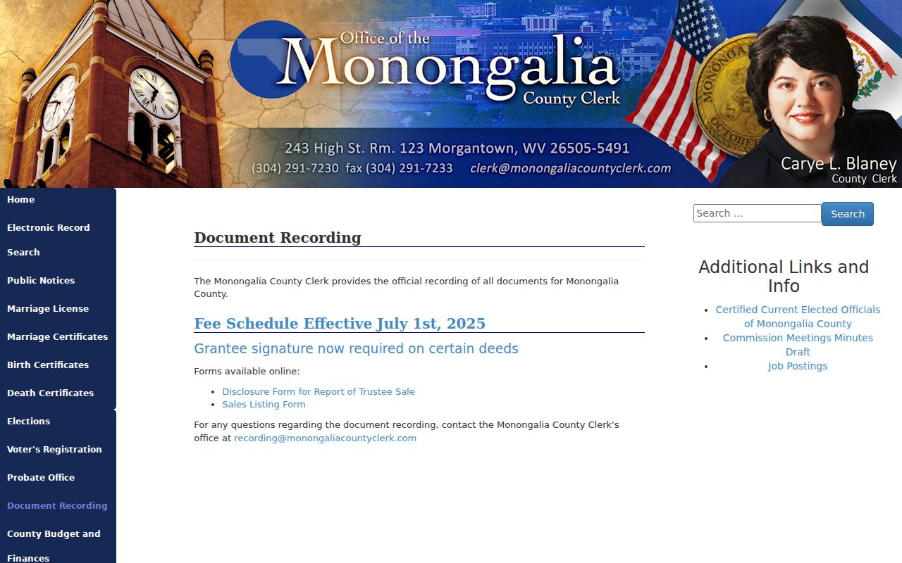
Confirm copy and older-book requests with the recording office.
Monongalia County Current and History
The Assessor database checks a "return current parcel info" option by default. Uncheck it to pull historical results. The distinction matters. A property may have changed hands, split, or been combined, and a current-only search can miss earlier assessment records. The portal also filters by development, deed type, dates, sale price, acreage, book, page, area, life estate, minerals, not mapped, void, and duplicate assessment.
Treat a history result as a clue. Confirm the transfer through the County Clerk. An old tax owner is not automatically the person who held title on a specific deed date. Save the version and year shown. Keep the parcel reference too, and search the prior owner as a grantee when ownership history is the goal.